I received the following link in an email from someone who reads my posts. It is a great place to check the weather. Very easy to read and very informative. It includes weather quality and has no ads.
Thanks For Watching! Be sure to like the video! In this video we talk about an upcoming major snowstorm that’s going to effect states in the rockies with Heavy Snowfall and powerful winds, these states include Washington, Montana, Idaho, California, Oregon, Wyoming, and more.
By Alex Sosnowski, AccuWeather senior meteorologist Updated Sep. 26, 2019 2:06 PM
While fall is not even a week old yet, some parts of the northern United States are bracing for a major snowstorm.
Parts of the Northwest and southern Canada are bracing for a potentially ‘historic’ snowstorm that will unleash heavy snow, fierce winds and record cold — and meteorologists say the timing of this storm will add to the dangers.
Hazardous travel conditions and power outages will result as blizzard conditions will unfold in some areas, according to AccuWeather meteorologists.
On Wednesday, the National Weather Service (NWS) in Missoula, Montana, warned that the storm has the potential to be “historic” due to its occurrence so early in the season. Life-threatening conditions in the backcountry and damaging winds were among the dangers the NWS office highlighted in a tweet.
AccuWeather spoke with Rebecca Connors, public information officer for the City of Helena Public Works, in anticipation of the early snowstorm.
“It’s Montana, and this is kind of the characteristic of Montana, freak snowstorms. Our seasons are short except for winter,” Connors told AccuWeather.
Montana crews are gearing up for the disruptive snowfall and preparing for the challenges an early-season storm presents, David Knoepke, transportation system director, said in an interview with AccuWeather.
“We’ll have to build up all of our snowplow trucks. We’re starting that today [Wednesday] into the weekend. It is a little bit earlier than typical, but not uncommon,” Knoepke told AccuWeather. “Our snow policy, strategy is that we’ll get the emergency snow routs done first and then go onto the rest of our priority routes and make sure that everything is sanded and cleared as appropriate to make travel safe.”
“I think some of it will be we have a lot of summer recreational things are parked in the parking lanes, boats, trailers, basketball hoops, that typically aren’t in there when our snow season really starts, so just maneuvering around all the extra vehicles that may be parked on the streets,” Knoepka added.
As the storm evolves, temperatures may plummet 50 degrees Fahrenheit (25 degrees Celsius) or more in some locations.
Those in the high country and intermediate elevations will be at risk for becoming stranded and could be in a life-threatening situation for a few days during and after the storm with below-freezing temperatures predicted.
The scene began to turn snowy at Logan Pass in Montana on Thursday, Sept. 26, 2019, the view from a webcam showed. Logan Pass sits at an elevation of 6,600 feet and will be hit this weekend by a major snowstorm. (Twitter / NWS)
The combination of clinging snow, increasing winds and leaves still on many of the trees will lead to large limbs coming down and power outages as the storm takes aim at Montana.
“It’s a very big concern here; we’re just beginning to turn our colors, so trees are fully loaded with foliage here,” LeeAnn Allegretto, a meteorologist with the NWS in Missoula, told AccuWeather. “Snow will have a huge impact and will likely cause downed trees and potentially plenty of damage/power outages.”
Winds are likely to average 15-25 mph (25-40 km/h) with gusts to 40-50 mph (65-80 km/h). Stronger gusts and sustained winds are likely during the height of the storm over the mountains and through the passes.
The combination of wind, snow and other conditions are forecast to cause AccuWeather RealFeel® Temperatures to dip below freezing and can approach zero F in some locations.
Over the high country, any rain to start will quickly change to snow late this week. Outside of the high country, the first part of storm will be rain late this week to early this weekend, but a change to snow is in store from north to south and to progressively lower elevations.
Travel conditions will deteriorate over the back roads in the high elevations first from Friday to early Saturday, but progress through the passes and then to roads at lower elevations as the storm continues later Saturday to Sunday.
Travel is likely to be difficult with slush and snow likely along stretches of Canada Highway 1 and interstates 15 and 94.
At times the combination of wind and snow will make for very low visibility that can approach blizzard conditions, including in Glacier National Park, Montana.
“Stay home. Stay safe. Don’t do anything silly,” public information officer for the City of Butte-Silver Bow, Jason Parish, told AccuWeather, should the weather bring the worst-case scenario for the city. He added that emergency services will be available as necessary to assist, but people should not take any unnecessary chances.
Butte-Silver Bow, Montana, is forecast to receive anywhere between three to six inches later this week.
Despite the storm occurring early in the season, Parish said that it is nothing new for the city.
“We’ve seen snow 12 months out of the year before. More than once we’ve sat at a Fourth of July parade and had snow falling,” Parish said.
The heaviest amount of snow, 1-2 feet, with a local AccuWeather StormMax™ of 40 inches is forecast along the east-facing slopes of the Sawtooth, Flathead and Lewis and Clark ranges in Montana.
However a general 1-2 feet (25-50 cm) of snow will fall over the mountains with anywhere from a bit of slush to several inches of snow at low elevations, including some of the valley floors in central and eastern Montana and British Columbia and the High Plains and Prairies of Alberta and Saskatchewan.
Up to a few inches of snow can fall over the mountains in northeastern Washington, the eastern foothills of the Cascades and northern Idaho.
Up to a foot of snow is forecast to fall on parts of Yellowstone National Park in northwestern Wyoming and south-central Montana.
Great Falls, Montana, is expected to receive 6-12 inches of snow. Accumulations around Calgary, Alberta, are likely to range from a few centimeters over the Prairies east of the city to 25 centimeters over the foothills to the west. The cities of Missoula, Montana, and Spokane, Washington, are likely to receive 1-3 inches of snow and slush from the storm this weekend.
The September snowfall in Missoula has the chance to be a record-setting event, Allegretto told AccuWeather. It’s been 36 years since September snow was recorded in Missoula. The Missoula Valley snowfall could turn out to be the greatest one-day September snowfall total since 1934 when 1.5 inches fell.
The vast area of fresh snow cover will set the stage for record-challenging low temperatures early next week.
Temperatures are likely to dip into the single digits over the high country and the teens and 20s F over the intermediate elevations to near or just below freezing in over the High Plains and Prairies during Sunday night, Monday night and perhaps Tuesday night.
Meanwhile, on the warmer side of the storm, southwest of the Continental Divide, locally heavy rain is likely to fall on part of the Great Basin, including the Salt Lake City area later this weekend. Localized flooding can occur.
Drenching showers will also pivot to the southeast of the snowstorm over parts of the Central Plains and the Upper Midwest.
The National Hurricane Center says the Lorenzo system is expected to become a hurricane within the next couple of days as it moves across the Atlantic, while Karen is back up to tropical storm strength as it nears Puerto Rico. 13News Now Meteorologist Tim Pandajis gives an update on the tropics and the overall 2019 Hurricane Season Subscribe to our YouTube Channel: https://13newsnow.tv/youtube Like us on Facebook: https://www.facebook.com/13NewsNow/ Follow us on Twitter: https://twitter.com/13newsnow Download the 13News Now App: https://13newsnow.tv/app Check out our website: https://www.13newsnow.com/
More than 1,000 rescued after Imelda hits Texas with dangerous flooding https://cbsn.ws/2m0jVn8 ‘Worse than Hurricane Harvey’: At least 2 dead as Imelda overwhelms Texas with’ incredibly dangerous’ flooding http://bit.ly/2mlu9i1 HURRICANE JERRY TRACK http://bit.ly/2kmxRay Late-summer snow coats mountains in Elko area http://bit.ly/2kreBJb More rain and mountain snow http://bit.ly/2kJKrkF Mammoth gets first snow of the season after a very short summer https://lat.ms/2kreNrT Weather radar picks up gigantic swarm of dragonflies over parts of southeast U.S. https://cbsn.ws/2kJQwgW LARGE HAIL, STRONG WINDS CAUSE DAMAGE IN AREA http://bit.ly/2lYW1II Cool summer, hail temper beet harvest expectations http://bit.ly/2ku8SlS Gene-edited animals will intensify factory farming and the climate crisis, could harm human health http://bit.ly/2kqRNJs Worldwide Volcano News and Updates: http://bit.ly/2v9JJhO Sheveluch LiveCam http://bit.ly/2keTUQs NASA emails reveal agency’s surprise at asteroid’s near-miss of Earth http://bit.ly/2kTyl8t The president’s NASA budget slashes programs and cancels a powerful rocket upgrade http://bit.ly/2lYlhPq There are 3 billion fewer birds in North America than there were in 1970 http://bit.ly/2mjan6O Fall Harvest Post Frost @3Canyons Permaculture Farm – Lactofermentation Selections https://www.youtube.com/watch?v=4fdWu… Why You Can’t Trust Nutrition Science & Health Claims http://bit.ly/2kKNoBt Public Schools, the Fixation of Belief, and Social Control http://bit.ly/2kqS6UC U.N. Stuns World on Eve of Largest Climate Events Ever http://bit.ly/2mlwolr Permaculture Soil Science & Solutions Kickstarter http://bit.ly/2m6pwIB GGD Growing Days Calculator Thanks To Ice Age Farmer http://iceagefarmer.com/gdd/ The Climate Revolution BOOK https://payhip.com/b/3sVi/af5d16bf1d8… LeakCon2019 Live-Stream Replay On Demand https://bit.ly/2TTbPIq Prepare With The Ranch – http://preparewiththeranch.com Leah and I are two humans who no longer support the inhuman, oligarchic empire model destroying our planet and our true nature as human beings. As activists we decided to do something about it, so we opted out of our former lives to begin anew. We are currently transforming pristine alpine wilderness into a self-sustaining homestead and organic farm in preparation for the upcoming collapse. We plan on developing and executing every single step of the process in open source format for the benefit of all humanity. With our backgrounds in academia and the sciences (climatology, geology, physics, biology, chemistry, and more) we hope to uncover the lies perpetrated by the mass media. It will be presented here and on our website in a systematic and thorough process. As you can imagine, this is a multifaceted, lifelong project, and we are so passionately excited to take the next steps towards self sufficiency and our dream! Won’t you join us? https://www.patreon.com/OppenheimerRa… ToPKnoT25 http://www.youtube.com/user/rhallgren… Check Out Our New Channel Magnetic Reversal News https://bit.ly/2Sic1os Oppenheimer Ranch Preparedness Store – BOOM! https://www.amazon.com/shop/oppenheim… Discord – Join The Discussion NOW – https://discord.gg/Mv9e8ud Oppenheimer Ranch Project Swag Store: https://teespring.com/stores/oppenhei… My Patriot Supply – The original Patriot survival company https://mypatriotsupply.com/?rfsn=170… HEMPLUCID – EXPERIENCE LIFE AGAIN 20% OFF + FREE SHIPPING Simply use the coupon code- BOOM (all caps) Oppenheimer Ranch Project Exclusive Link https://lddy.no/4a7z One Time Donations: https://www.paypal.me/OppenheimerRanc… Bitcoin: 17NV3vtcQhRnsRnjckCcYkKVEUcnirKQ62 Steemit: https://steemit.com/@solarshutdownhttps://www.minds.com/OppenheimerRanc… Oppenheimer Ranch Project: An experiment in high alpine sustainability. https://www.facebook.com/oppenheimerr… Please SUBSCRIBE to our channel if you enjoyed the content. Share this video with like-minded individuals
In the entire history of our country, a hurricane has never made landfall in the state of California. So if such a thing actually happened, it would be considered to be an extremely unusual event. Well, right now there are three very dangerous tropical storms swirling in the eastern Pacific Ocean. Tropical Storm Kiko is not expected to be a serious threat to make landfall, but Tropical Storm Lorena and Tropical Storm Mario “are expected to become hurricanes by Friday as they approach the Mexican coast”. Tropical Storm Lorena is the more immediate threat, and the latest forecast is projecting that it will reach Mexico’s Baja California Peninsula by Saturday. If it maintains hurricane strength and continues to ride up the west coast, it is entirely possible that we could see something that we have never seen before. Most forecasters don’t want to talk too much about it yet, because it truly would be an unprecedented event, but there really is a chance that California could get hit by a hurricane for the very first time in U.S. history. Learn More: https://www.zerohedge.com/health/cali…
People abandon vehicles, evacuate homes due to flooding; Chambers County Sheriff Brian Hawthorne described flooding in their county from Imelda as worse than Hurricane Harvey in 2017.
I am in Galveston Texas keeping track of the heavy rain and other impacts from what was once tropical storm Imelda. Using the iPad here is a look at all of the happenings in the tropics.
The tropical depression is bringing “significant and life threatening flash flooding,” the National Weather Service said.
By David K. Li and Annie Rose Ramos
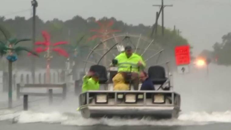
HOUSTON — Tropical Depression Imelda brought driving rains to Louisiana and southeast Texas on Thursday, prompting evacuations and inundating many of the same communities ravaged by Hurricane Harvey two years ago.
As much as 40 inches of rain could fall in the region on Thursday and Friday, as “significant and life threatening flash flooding is ongoing across portions of far southeast Texas,” according to an advisory from the National Hurricane Center.
Crews have rescued more than 1,000 people in the Houston area, mostly in eastern Harris County, because of rising waters, officials said.
“What we need is for folks to stay calm … and stay home,” Harris County Judge Lina Hildago, the county’s chief executive, told reporters. “The best thing you can do is remain indoors, wherever you are, to not go outside.”
And all bus and rail service has been shut down in Houston, Texas’ biggest city and the fourth largest in America, the area’s public transportation agency announced.
More than 70,000 homes and businesses in Texas, almost all in the southeast corner in the Houston area, were without power late Thursday afternoon, according to Poweroutage.us.
Both of Houston’s airports were affected by extreme rain.
The roof of a United State Postal Service distribution facility on Aldine Bender Road in Houston collapsed during the storm at about 10:30 a.m., and three people were transported with minor injuries, Houston firefighters said.
It wasn’t immediately clear if the collapse was directly connected to the heavy rains, a USPS spokeswoman said.
Houston Fire Dept
@HoustonFire
HFD is responding to a building collapse on Aldine Bender Road. The flat roof of a post office facility mail distribution area collapsed. The building was occupied at the time but everyone made it out. 3 people are being transported with minor injuries. @FireChiefofHFD
Flood waters forced the hasty evacuation Thursday of Riceland Medical Center in Winnie, about 60 miles east of downtown Houston.
“It’s as bad as I’ve ever seen it. Right now I’m in an absolute deluge of rain,” Chambers County Sheriff Brian Hawthorne said Thursday morning, as he took cover under a carport at an auto dealership.
Cars drive through a flooded street in Sargent, Texas, on Sept. 18, 2019.Mark Mulligan / Houston Chronicle via AP
“Right now, as a Texas sheriff, the only thing that I really want is for people to pray that it will quit raining.”
He added that the town “looks like a lake.”
James Revia, a 40-year-old resident of the Chambers County community of Hankamer, and his four children were rescued from their flooded trailer park home by a passing fire truck.
Revia, who owns a lawn service and is a mobile DJ, fears all of his music equipment, kept inside his truck, has been lost to floods.
“This storm grew into a tropical depression within four hours, it caught everyone by surprise,” he told NBC News.
Erika Zamora, who was stranded with her five children and husband inside their home, said the rain in Winnie was unrelenting.
“I opened the door and the water was to our door,” Zamora said.
A neighbor with a rescue boat fetched them to safety, but the family believes they’ve lost almost all of their belongings in their mobile home.
“This is my family, these are my kids and I’m pregnant. It was scary,” a tearful said Zamora Thursday at a local school cafeteria-turned-evacuation center.
In Beaumont, about 85 miles northeast of Houston, flood waters are going above and beyond what Hurricane Harvey did in August 2017, officials said.
“It’s bad,” Jefferson County Judge Jeff Branick said. “Homes that did not flood in Harvey are flooding now.”
By midday, a rain gauge just outside of Beaumont is reporting a two-day rainfall total now over 38 inches, with 34 inches coming down in the last 24 hours.
Texas Gov. Greg Abbott on Thursday declared a state of emergency in counties suffering from the heavy rains and floods: Brazoria, Chambers, Galveston, Hardin, Harris, Jasper, Jefferson, Liberty, Matagorda, Montgomery, Newton, Orange and San Jacinto.
Annie Rose Ramos reported from Houston, David K. Li reported from New York.
SOUTH MISSISSIPPI (WLOX) – In the tropics, Tropical Storm Jerry formed on Wednesday morning, joining Major Hurricane Humberto and Tropical Depression Imelda on the map. Thankfully, there continue to be no threats to Mississippi.
TROPICS VIDEO: 9-18-19 T.S. Jerry to become a hurricane. Models keep it out of the Gulf.
TROPICAL STORM JERRY expected to become a hurricane
Newly formed Tropical Storm Jerry in the Atlantic, previously Tropical Depression Ten, is still expected to become a hurricane as it approaches the Bahamas early next week.
At this time, Jerry is not considered a threat to the Gulf Coast. Most computer models turn Jerry northward when it reaches the Bahamas. But, some don’t, allowing it to get closer to the Gulf. So, we’ll be watching its developments in case there are any changes.
9-18-19 Thursday AM tropics update (Source: WLOX)
9-18-19 Thursday AM tropics update (Source: WLOX)
9-18-19 Wednesday AM tropics update (Source: WLOX)
HURRICANE HUMBERTO moving away from U.S., approaching Bermuda today
Major Category Three Hurricane Humberto was located about 600 miles offshore of South Carolina, moving east-northeastward, away from the U.S. mainland on Wednesday morning.
Humberto is forecast to continue growing stronger today as it approaches Bermuda.
Hurricane-force winds (greater than 74 mph) are expected to reach Bermuda tonight and continue into early Thursday morning. Winds are expected to reach tropical-storm strength (greater than 39 mph) later this afternoon, making outside preparations difficult or dangerous. Preparations to protect life and property should be rushed to completion. Humberto may bring periods of heavy rain to Bermuda through Thursday, with rainfall accumulations of 2 to 4 inches with maximum amounts of 6 inches expected. Large swells generated by Humberto will increase along the coast of Bermuda today. Dangerous breaking waves, especially along south-facing beaches, will be possible Wednesday night into Thursday, and could cause coastal flooding. Swells will continue to affect the northwestern Bahamas and the southeastern coast of the United States from east-central Florida to North Carolina during the next couple of days. These swells could cause life-threatening surf and rip current conditions. Storm surge and breaking waves could raise water levels by 1 to 3 feet above normal tide levels along the immediate southern coast of Bermuda.
Humberto remains no threat to the Gulf of Mexico
9-18-19 Thursday AM tropics update (Source: WLOX)
9-18-19 Thursday AM tropics update (Source: WLOX)
9-18-19 Thursday AM tropics update (Source: WLOX)
TRACKING TWO TROPICAL WAVES with a low chance to develop
A tropical wave located several hundred miles west of the Cape Verde Islands is producing disorganized cloudiness and showers. Some development of this disturbance is possible over the weekend while the system approaches the Windward Islands or across the southeastern Caribbean Sea early next week.
A tropical wave is forecast to move off of the west coast of Africa on Thursday. Development, if any, is expected to be slow to occur through early next week while the system moves generally westward at 10 to 15 mph.
The next two names on the list are Karen and Lorenzo.
9-18-19 Wednesday AM tropics update (Source: WLOX)
You can always track the tropics with the WLOX Weather App. See video below for a quick how to:
How to track tropics anytime anywhere with the WLOX Weather App
We are now in the heart of hurricane season when we tend to see the most tropical activity during this time of year. Hurricane season officially ends on November 30.
A massive storm battering the Gulf Coast is just one of three potentially dangerous weather systems being followed by meteorologists Wednesday. Hurricane Humberto is a powerful, category three storm that’s approaching Bermuda. Tropical storm Jerry is expected to strengthen into a hurricane later this week. And flash flood watches are in effect from southeastern Texas up through Louisiana, as tropical depression Imelda pushes inland. Jeff Berardelli has the latest forecast.
More Updates 9/13/19
New Potential Tropical Storm Threatens Bahamas
A new weather system was expected to bring heavy rain to the area on Friday and Saturday.
Storm clouds over the ocean near Nassau, Bahamas, on Thursday.CreditCreditAndrew Caballero-Reynolds/Agence France-Presse — Getty Images
A potential tropical storm is brewing in the Atlantic and by late Friday could threaten areas of the Bahamas recently devastated by Hurricane Dorian, forecasters warned.
The new storm is not expected to pack nearly the destructive power of Dorian, a Category 5 hurricane that killed at least 50 people and left widespread damage across the islands. But it could pose a challenge to rescuers, who were still searching for about 1,300 missing people as of Thursday.
The storm would be named Humberto if it becomes strong enough to be classified as the year’s ninth tropical storm.
On Friday morning, a tropical storm warning was in effect for the northwestern Bahamas, excluding Andros Island, meaning that tropical storm conditions are expected in the area within 36 hours. A tropical storm watch, which means storm conditions are possible within the next 48 hours, was in effect for the part of the Florida’s eastern coastline that stretches approximately from West Palm Beach to Daytona Beach.
At 11 a.m. Friday, the approaching storm system, packing sustained wind speeds of 30 miles per hour, was about 190 miles southeast of the hard-hit Abaco Islands, according to the National Hurricane Center. It was expected to gain strength and bring tropical storm-force winds — defined as sustained winds of 39 to 73 miles per hour — and heavy rainfall to the northwest Bahamas on Friday and Saturday, forecasters said. A tropical storm warning was in effect for much of the area.
Parts of Florida’s east coast could get tropical storm-force winds over the weekend, and residents were advised to monitor the storm’s progress. The storm was moving very slowly as of late Friday morning, at just one mile per hour, but forecasters expected it to gain some speed through the weekend.
Significant storm surge was not expected, forecasters said. But parts of the Bahamas were expected to get two to four inches of rain, and up to six inches in some isolated spots, while the eastern coast of the United States from Central Florida through South Carolina could get two to four inches.
The National Hurricane Center said at 11 a.m. Friday that it was 80 percent likely to reach that strength within 48 hours, and 90 percent likely within five days.
Jacey Fortin contributed reporting
ANOTHER POSSIBLE HURRICANE IN THE AREA OF THE NORTH BAHAMAS… AN ATTEMPT TO FINISH THE JOB?
Cheryl McCloud, Fort Myers News-PressPublished 5:52 a.m. ET Sept. 13, 2019 | Updated 8:16 a.m. ET Sept. 13, 2019
Hurricanes, cyclones and typhoons are the same weather phenomenon; tropical cyclones. Ginny Beagan, TCPALM
Tropical storm watches and warnings have been issued ahead of Potential Tropical Cyclone Nine, one of three systems in the Atlantic basin being monitored by the National Hurricane Center.
Tropical storm watches were issued for from Jupiter Inlet north to the Flagler-Volusia County line on Florida’s East Coast.
If it becomes a tropical storm as expected today, it would be named Humberto.
Tropical storm warnings were issued for the northwest Bahamas, still trying to recover from Hurricane Dorian earlier this morning.
Potential Tropical Cyclone Nine
Location: 235 miles east-southeast of Freeport, Grand Bahama Island
Maximum sustained winds: 30 mph
Movement: northwest at 6 mph
At 8 a.m., the center of the disturbance was 235 miles east-southeast of Freeport, Grand Bahama Island.
The system is moving toward the northwest near 6 mph, and this general motion is expected to continue with some increase in forward speed through the weekend.
On the forecast track, the system is anticipated to move across the central and northwestern Bahamas today, and along or over the east coast of Florida Saturday and Saturday night.
We are getting lightning and thunder which is rare in hurricane and I am hearing a very HIGH pitch sound in my ear and I’m not the only one hearing it. I also have an ultrasound detector and it started going off about 5 minutes ago after the thunder started… Things that make you go Hummmm?
FL, GA, SC, NC Subscribers – let us know what’s going on. Stay safe, y’all. Should you want to donate, I would very much appreciate it. I have a PayPal account under smilinrocks@gmail.com. Thank you
Rick Sanchez discusses the much-hyped destructive potential of Hurricane Dorian and why it has dominated the establishment news. He examines the ominous possibility that the US may be incapable of dealing with hurricanes.


@HoustonFire


 Get on my private Email List while this channel still exists: http://bit.ly/HighImpactFlixOfficial (don’t forget to CONFIRM)
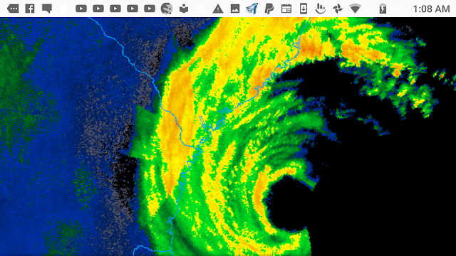
 LIVE FROM TEXAS NEWS STUDIO: LATEST NEWS||WEATHER||BREAKING ALERTS

1st blizzard of season to wallop northern US with up to 3 feet of snow
By Alex Sosnowski, AccuWeather senior meteorologist
Updated Sep. 26, 2019 2:06 PM