 |
Here we are in a new month. Once again I want to state very clearly that I am not a reliable source for your daily weather. I am not even a reliable source for your weather alerts. I do try to stay up on what is happening with the weather. But, I am a single working mom with a handicapped son, so I stay pretty busy. When I notice something that is happening with the weather, I will post it. Look on this site as just additional information to what you already know about your weather.
With that said, here are the updates for today.
10-5-19 Below is the Current Flood Gauge situation. As you can see the Middle of the country continues to remain in the FLOODING RANGE. This has been the case for this entire year! All of you who live in the areas where you see the little squares…better know the condition of the dams in your area! Our dams are all in seriously sad condition. They cannot hold up much longer, especially under this kind of pressure
Update 3/29/21
I received the following link in an email from someone who reads my posts. It is a great place to check the weather. Very easy to read and very informative. It includes weather quality and has no ads.
CLIMACELL
Link: https://www.climacell.co/weather/
Update 10/28/19
October 28, 2019
PM Update 10/25/19
October 25, 2019
Update 10/25/19
October 24, 2019
Update 10/21/19
October 21, 2019
PM Update 10/18/19
October 18, 2019
October 18, 2019
Update 10/18/19
![]()

National Weather Service
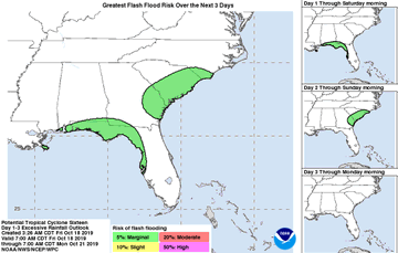
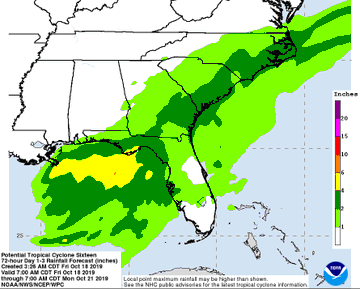
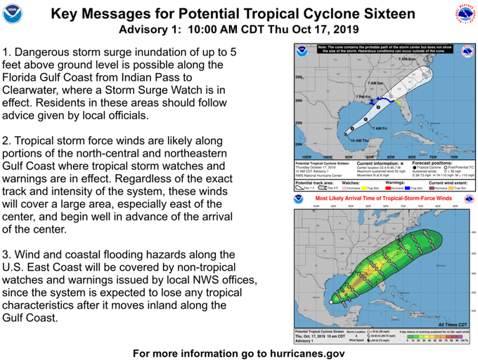
A storm system in the Gulf of Mexico is expected grow into a tropical storm over the weekend and then hit the Florida Panhandle as early as Saturday morning, according to the National Hurricane Center.
The storm, tagged as Tropical Cyclone 16, is about 230 miles south of the Mississippi river as of Friday morning. It’s currently moving northeast at 22 mph, with maximum sustained winds at 60 mph.
If Tropical Cyclone 16 strengthens into a tropical storm, it will be called Nestor.
The storm is predicted to bring strong winds, heavy rainfall and flash flooding to impacted areas. Tropical storm warnings have been posted from Yankeetown, Fla. to the Alabama-Mississippi line and from Grand Isle, Louisiana to the mouth of the Pearl River.
Florida Gov. Ron DeSantis tweeted that the government is monitoring the storm and that residents should prepare for possible flooding and power disruptions.
After hitting Florida, the storm is projected to continue traveling northeast, exiting into the Atlantic Ocean somewhere around the Outer Banks of North Carolina Sunday or early morning.
Georgia is expected to get hit with heavy rain and wind gusts Saturday afternoon. The Carolinas could feel the effects early Sunday morning.
In New Orleans, two cranes that are standing over a partially destroyed hotel are being taken down by crews to prevent them from being destructive when the winds hit, according to the AP.
Friday night high school football games from Alabama to the Florida panhandle have been canceled or postponed in preparation of the storm, according to the AP.
Parts of Florida that are expected to be hit by the tropical storm are still recovering from the devastation that Hurricane Michael left one year ago.
Officials in Panama City reassured residents that the storm wouldn’t be a repeat of Hurricane Michael.
“We are optimistic this will be a slight wind and rain event,” Bay Count Sheriff Tommy Ford said, according to the AP.
Update 10/17/19
October 14, 2019
Update 10/14/19
October 14, 2019
October 13, 2019
October 13, 2019
Update 10/11/19
THE MIDWEST FARMERS CONTINUE TO GET BATTERED BY THE WEATHER!
An “All-Out Blizzard” That Is “Unheard Of For October” Is About To Hit Farms In The Midwest With Up To 2 Feet Of Snow
Farmers in the middle of the country are about to get hit by what could potentially be the worst October blizzard in U.S. history. According to USA Today, “the massive size and intensity of this snowstorm is unheard of for October”. In other words, we have never seen anything like this in the month of October ever before. Such a storm would have been disastrous enough in a normal year, but this has definitely not been a normal year for Midwest farmers. As I detailed extensively in previous articles, endless rain and horrific flooding made planting season a complete and utter nightmare for many Midwest farmers this year. Millions of acres did not get planted at all, and planting was seriously delayed on tens of millions of other acres. As a result, corn, soybeans and other crops are simply not ready to be harvested in many parts of the Midwest, and now an unprecedented winter storm is barreling directly toward our heartland.
This is a very, very serious situation. Normally, most corn in the Dakotas and Minnesota is considered to be “mature” by now, but this year we are facing a completely different scenario.
According to the latest USDA Crop Progress Report, only 22 percent of the corn in North Dakota is considered to be “mature” at this point…
Many farmers continue to wait on the sidelines to get into the fields. With freezing temperatures, heavy snowfall, and high winds set to hit the northern Plains this week, the corn in North Dakota is only 22% mature vs. a 75% five-year average, according to Monday’s USDA Crop Progress Report.
Also, South Dakota corn is rated 36% mature vs. an 80% five-year average. Minnesota farmers have a corn crop that is just 39% mature vs. an 83% five-year average.
And now here comes an “all-out blizzard”.
In case you are wondering, I am not the one that put such an extreme label on this storm. In fact, Accuweather is specifically using that term to describe this historic storm…
An unusually far-reaching snowstorm for early October will stall, strengthen and evolve into an “all-out blizzard” over the Dakotas and then will send a blast of cold air across much of the Plains and Midwest.
Heavy snow has already fallen on the northern Rockies and was progressing southeastward along with a charge of cold air. Snow and slippery travel were also being reported in parts of Washington state, including around Spokane where new daily snowfall record for Oct. 8 was set. Spokane International Airport recorded 3.3 inches of snow Tuesday, shattering the previous record for the day, which was a trace set in 1981.
It is crazy that Spokane is already getting snow.
According to Yahoo News, that snowfall already makes this the “third-snowiest October” that the city has ever experienced…
Spokane, Washington, was one town that was hit particularly hard by the snow on Tuesday. A record-breaking 3.3 inches of snow fell, the first measurable snow in the month of October since 2001. It also made this month the third-snowiest October on record, following 3.9 inches in October of 1975 and 6.1 inches in October of 1957.
Ultimately, a few inches of snow is not that big of a deal.
But once this storm reaches the middle of the country, it is going to dump up to 2 feet of snow on some of our most important agricultural areas…
A general 6-12 inches is forecast over much of the Dakotas. However, a large swath of 12-24 inches is likely with an AccuWeather Local StormMax™ of 30 inches likely from north-central North Dakota to central and northeastern North Dakota.
Cities that could end up with 2 feet of snow include Bismarck, Jamestown and Devils Lake, North Dakota, as well as Mobridge, South Dakota, and Winnipeg, Manitoba.
Needless to say, that much snow at this time of the year is going to be absolutely devastating for many farmers.
And we are being told that this coming storm actually has “two parts”. After the first part strikes, the second part is going to come rolling through on Friday and Saturday…
The storm will have two parts, the first of which is targeting the northern and central Rockies and High Plains on Wednesday into Thursday. The second part will bring snow to the eastern and central portions of the Dakotas and western Minnesota by week’s end.
“Near-blizzard to full-fledged blizzard conditions are possible across portions of central North Dakota Friday afternoon into Saturday morning,” the weather service in Bismarck said. “Expect high impacts and dangerous to impossible travel conditions.”
I can’t even imagine how corn and soybean farmers are going to feel once their unharvested fields are buried under two feet of snow.
As I keep warning, weather patterns just continue to become more extreme, and many believe that what we have witnessed so far is just the beginning of our problems.
There is one more thing that I would like to mention before I wrap up this article.
Do you remember the “Perfect Storm” that we witnessed in the Atlantic Ocean back in 1991? Hollywood made a big movie about it, and that film ended up making more than 300 million dollars worldwide.
Well, according to Accuweather a very similar storm is now developing in roughly the same location…
Interestingly, around the same time in 1991, the “Perfect Storm” was in the making over the western Atlantic Ocean. There are some similarities to the pattern this week with a smaller storm taking shape and stalling just off the mid-Atlantic and New England coasts.
I found this to be particularly interesting, because I wrote an article about “the perfect storm” that is about to hit America just a few days ago. If you missed it, you can find my article entitled “The Book Is About To Close On The Late Great United States Of America” right here.
We live in truly unprecedented times, and things are about to start getting really crazy out there.
So get prepared for “the perfect storm” while you still can, because time is quickly running out.
About the author: Michael Snyder is a nationally-syndicated writer, media personality and political activist. He is the author of four books including Get Prepared Now, The Beginning Of The End and Living A Life That Really Matters. His articles are originally published on The Economic Collapse Blog, End Of The American Dream and The Most Important News. From there, his articles are republished on dozens of other prominent websites. If you would like to republish his articles, please feel free to do so. The more people that see this information the better, and we need to wake more people up while there is still time. Of course the most important thing that we can share with people is the gospel of Jesus Christ, and if you would like to learn more about how you can become a Christian I would encourage you to read this article.
Update 10/10/19
Temperatures could drop 50 degrees in 24 hours ahead of historic snowfall

A drastic temperature drop Wednesday will make it feel like Denver has gone from fall to winter in 24 hours.Temperatures there will plummet from a high around 80 degrees Fahrenheit Wednesday to below freezing for Thursday’s high.Much of Colorado will transition from hazardous fire conditions to a freeze warning in only a matter of hours.Once the temperatures drop, record lows are likely to be broken across much of the region.This temperature plunge will start in the northern Rockies and dive southward to parts of northern Texas by Friday morning. Freeze watches and warnings stretch from Nebraska to Texas.Other notable temperature drops this week include:• Amarillo: From 85 degrees to 29 degrees in 36 hours• Minneapolis: From 65 degrees to 33 degrees in 33 hours• Kansas City: From 71 degrees to 41 degrees in 15 hours• Albuquerque: From 70 degrees to 29 degrees in 15 hours• Oklahoma City: From 74 degrees to 39 degrees in 18 hours• Lubbock: From 80° to 34° in 16 hours• Chicago: From 68 degrees to 38 degrees in 18 hoursSnow totals could break records
The National Weather Service office in Bismarck is referring to this storm as a “potentially historic October winter storm”, as parts of 10 states are under some sort of winter watch, warning or advisory from the northern Rockies to the northern Plains.The storm could shatter October snow records across much of the Dakotas as it intensifies Wednesday evening and dumps 1 to 2 feet of snow through Thursday night.Along with the snow, wind gusts of 40-50 mph or more are expected, producing possible blizzard conditions and making travel extremely dangerous. Along with blowing snow, the winds could bring down trees and power lines, resulting in power outages and whiteout conditions on the roads. Expect treacherous travel on the roads and well as airport delays through the end of the week.The snow will continue into Friday for portions of eastern North and South Dakota, before moving into portions of Minnesota by Saturday. The storm system intensifies and moves Wednesday night into the northern Plains, with winter storm warnings issued there and 1 to 2 feet of snow expected.Extreme winds could lead to whiteouts
Wind gusts stronger than 20 mph can be expected across the Denver region, with parts of Montana getting gusts over 30 mph. In addition to falling limbs, these winds will also contribute to blowing snow conditions, diminishing visibility on roads.The snowstorm by Saturday will reach as far east as Minneapolis before the system moves into Canada.
As for today… it looks like Wisconsin is a major target. Beware, stay alert, prepare!

These are the national weather forecasts for the next three days.
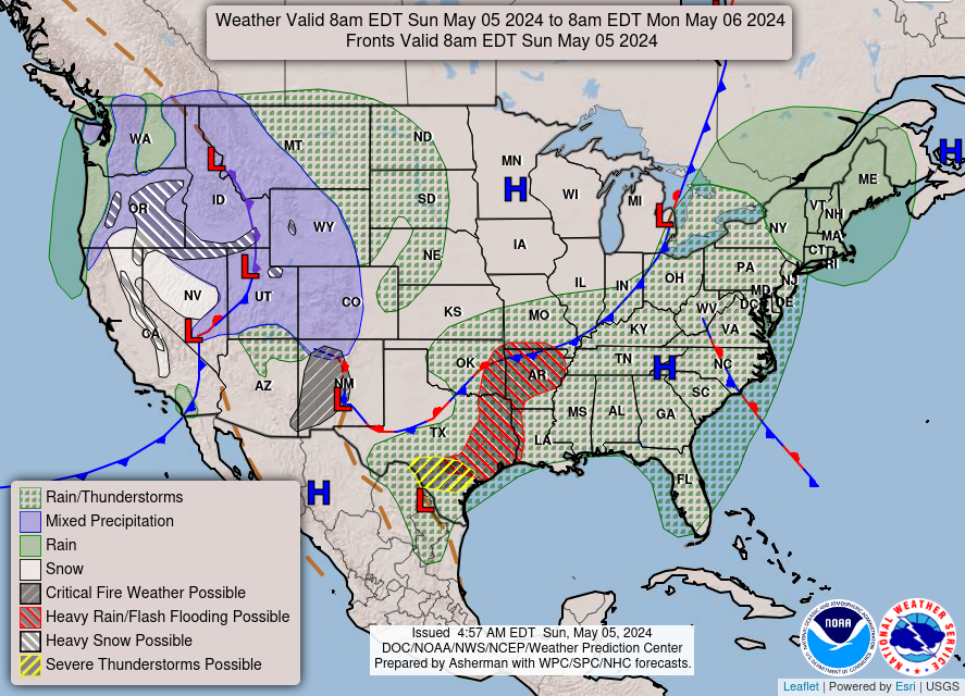
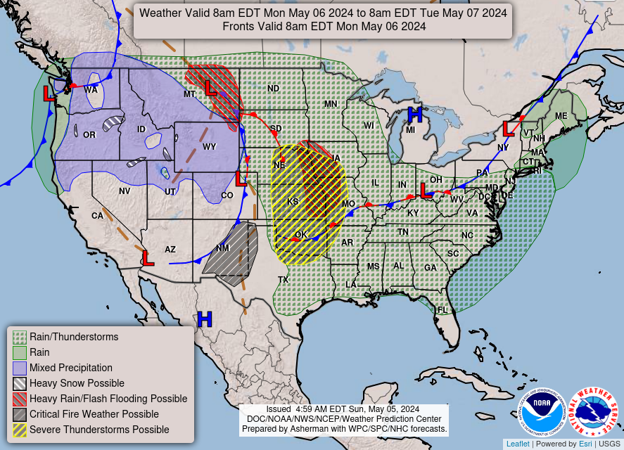
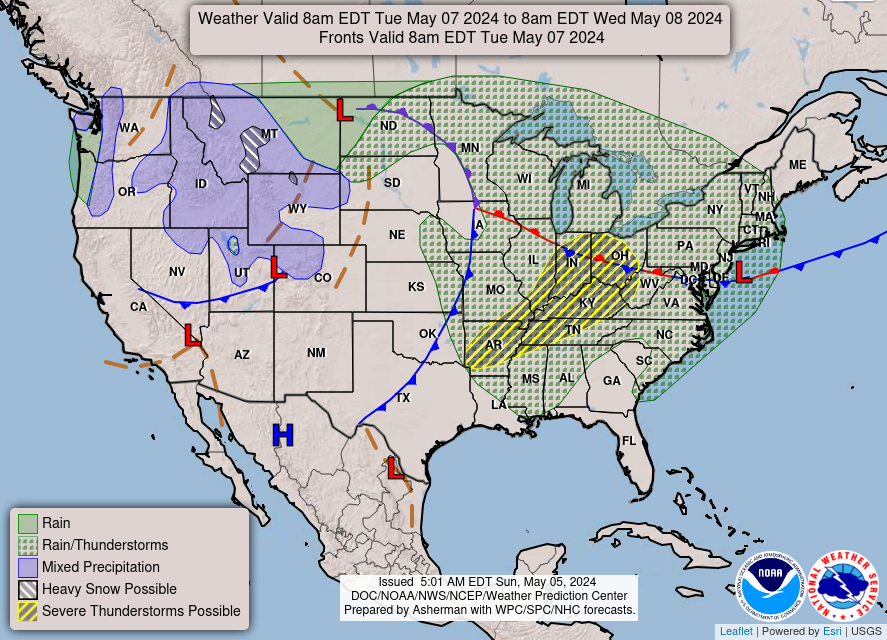
Watches, Warnings or Advisories for
Wisconsin
This page shows alerts currently in effect for Wisconsin and is normally updated every two-three minutes. Please see here for other state and listing by county.
| Last updated: 04:47 CDT on 10-05-2019 |
It looks as if North and South Dakota, and Montana are getting hit hard today as well.

Hazardous Weather Outlook
National Weather Service Rapid City SD
437 AM MDT Sat Oct 5 2019

SDZ001-002-012>014-025-026-031-032-043-044-046-047-049-072-073-
061300-
Harding-Perkins-Butte-Northern Meade Co Plains-Ziebach-
Northern Foot Hills-Rapid City-Pennington Co Plains-Haakon-
Jackson-Bennett-Mellette-Todd-Tripp-Sturgis/Piedmont Foot Hills-
Southern Meade Co Plains-
437 AM MDT Sat Oct 5 2019 /537 AM CDT Sat Oct 5 2019/

This Hazardous Weather Outlook is for portions of western South
Dakota.

.DAY ONE...Today and Tonight

Windy conditions can be expected for today. A wind advisory is in
effect for much of the South Dakota plains through afternoon.

.DAYS TWO THROUGH SEVEN...Sunday through Friday

Accumulating snow will be possible Wednesday into Thursday of
next week, along with gusty winds.

.SPOTTER INFORMATION STATEMENT...

Spotter activation will not be needed today.

&&

Stay tuned to NOAA weather radio for further updates...or check
our web site at weather.gov/rapidcity

$$
Hazardous Weather Outlook
National Weather Service Bismarck ND
618 AM CDT Sat Oct 5 2019

NDZ025-036-037-046>048-050-051-061130-
Foster-Kidder-Stutsman-Emmons-Logan-La Moure-McIntosh-Dickey-
618 AM CDT Sat Oct 5 2019

This Hazardous Weather Outlook is for portions of south central
North Dakota and southeast North Dakota.

.DAY ONE...Today and Tonight

A few thunderstorms will continue this morning. Severe weather is
not expected.

A Wind Advisory is in effect today for northwest wind gusts near
45 mph. See www.weather.gov/bis for further details.

.DAYS TWO THROUGH SEVEN...Sunday through Friday

A widespread hard freeze is becoming increasingly likely Wednesday
night and Thursday night.

.SPOTTER INFORMATION STATEMENT...

Spotter activation will not be needed.

$$
Hazardous Weather Outlook
National Weather Service Bismarck ND
618 AM CDT Sat Oct 5 2019

NDZ040>045-061130-
Slope-Hettinger-Grant-Bowman-Adams-Sioux-
618 AM CDT Sat Oct 5 2019 /518 AM MDT Sat Oct 5 2019/

This Hazardous Weather Outlook is for portions of south central
North Dakota and southwest North Dakota.

.DAY ONE...Today and Tonight

A Wind Advisory is in effect today for northwest wind gusts near
45 mph. See www.weather.gov/bis for further details.

.DAYS TWO THROUGH SEVEN...Sunday through Friday

A widespread hard freeze is becoming increasingly likely Wednesday
night and Thursday night.

.SPOTTER INFORMATION STATEMENT...

Spotter activation will not be needed.

$$
Hazardous Weather Outlook
National Weather Service Billings MT
435 AM MDT Sat Oct 5 2019

MTZ032-033-036-037-061045-
Custer-Fallon-Powder River-Carter-
435 AM MDT Sat Oct 5 2019

This Hazardous Weather Outlook is for portions of southeast
Montana.

* WHAT...Strong wind gusts today. Coldest air of the season arrives
  mid week, with accumulating snow possible.

* WHERE...Southeast Montana.

* Strong wind gust details...West winds gusting 30 to 50 mph today
  will make travel difficult for high profile vehicles, especially
  on north to south oriented roadways.

* Strong cold front Wednesday...High temperatures near 70 on
  Tuesday will drop into the 30s for Wednesday, Thursday and
  possibly Friday. Accumulating snow is forecast for lower
  elevation locations Wednesday and Thursday, though its still too
  early to pinpoint amounts. Travel and outdoor activities may be
  impacted by winter conditions, so plan accordingly.

PRECAUTIONARY/PREPAREDNESS ACTIONS...

A Hazardous Weather Outlook is issued when hazardous weather could
impact the region within the next week. Be sure to stay tuned for
future updates as locations, timing, and impacts could change.
Begin preparations to mitigate any impacts that could result from
the hazardous weather.

&&

$$
Hazardous Weather Outlook
National Weather Service Billings MT
435 AM MDT Sat Oct 5 2019

MTZ028>031-034-035-038>042-056>058-063>068-WYZ098-099-061045-
Southern Wheatland-Musselshell-Treasure-Northern Rosebud-
Northern Stillwater-Yellowstone-Southern Big Horn-Eastern Carbon-
Northern Park-Northern Sweet Grass-Golden Valley-
Red Lodge Foothills-Northern Big Horn-Southern Rosebud-Judith Gap-
Paradise Valley-Livingston Area-Beartooth Foothills-
Absaroka/Beartooth Mountains-Crazy Mountains-
Northeast Bighorn Mountains-Sheridan Foothills-
435 AM MDT Sat Oct 5 2019

This Hazardous Weather Outlook is for portions of central
Montana...south central Montana...southeast Montana and north
central Wyoming.

* WHAT...Coldest air of the season arrives mid week.

* WHERE...Southern Montana and Northern Wyoming.

* WHEN...Wednesday through Friday.

* ADDITIONAL DETAILS...High temperatures near 70 on Tuesday will
  drop into the 30s for Wednesday, Thursday and possibly Friday.
  Accumulating snow is forecast for lower elevation locations
  Wednesday and Thursday, though its still too early to pinpoint
  amounts.

* ADDITIONAL HAZARD CONCERNS...Coldest temperatures of the season
  are expected mid to late week. Travel and outdoor activities may
  be impacted by winter conditions, so plan accordingly.

PRECAUTIONARY/PREPAREDNESS ACTIONS...

A Hazardous Weather Outlook is issued when hazardous weather could
impact the region within the next week. Be sure to stay tuned for
future updates as locations, timing, and impacts could change.
Begin preparations to mitigate any impacts that could result from
the hazardous weather.

&&

$$
Note that this Alert is also for Minnesota and Iowa as well as South Dakota.
Hazardous Weather Outlook
National Weather Service Sioux Falls SD
412 AM CDT Sat Oct 5 2019

IAZ001-MNZ071-072-080-081-097-098-SDZ038>040-050-052>070-060915-
Lyon-Lincoln-Murray-Cottonwood-Pipestone-Rock-Beadle-Kingsbury-
Brookings-Gregory-Jerauld-Sanborn-Miner-Lake-Moody-Brule-Aurora-
Davison-Hanson-McCook-Minnehaha-Charles Mix-Douglas-Hutchinson-
Turner-Bon Homme-Yankton-Clay-
412 AM CDT Sat Oct 5 2019

This Hazardous Weather Outlook is for portions of northwest Iowa,
southwest Minnesota, central South Dakota, east central South
Dakota, south central South Dakota, and southeast South Dakota.

.DAY ONE...Today and Tonight

West to northwest winds will gust to around 45 mph at times late
this morning into the afternoon.

Isolated showers this afternoon could produce some pea sized hail
as well as wind gusts around 50 mph. The better chances would be
from Huron to Brookings to Marshall Minnesota.

.DAYS TWO THROUGH SEVEN...Sunday through Friday

Hazardous weather is not expected at this time.

.SPOTTER INFORMATION STATEMENT...

Spotter activation is not expected at this time.

$$
There are Hazardous Weather Alerts Currently for MAINE as well.
Hazardous Weather Outlook
National Weather Service Caribou ME
704 AM EDT Sat Oct 5 2019

MEZ001>006-010-011-015>017-029>032-061115-
Northwest Aroostook-Northeast Aroostook-Northern Somerset-
Northern Piscataquis-Northern Penobscot-Southeast Aroostook-
Central Piscataquis-Central Penobscot-Southern Penobscot-
Interior Hancock-Central Washington-Coastal Hancock-
Coastal Washington-Southern Piscataquis-Northern Washington-
704 AM EDT Sat Oct 5 2019

This Hazardous Weather Outlook is for Central Highlands Maine,
Coastal DownEast Maine, Far Eastern Maine, Far Northern Maine,
Interior DownEast Maine, North Woods Maine and Penobscot Valley
Maine.

.DAY ONE...Today and Tonight.

A clear sky and calm air tonight will result in a hard freeze across
the north and frost Downeast.

.DAYS TWO THROUGH SEVEN...Sunday through Friday.

No hazardous weather is expected at this time.

.SPOTTER INFORMATION STATEMENT...

Weather spotters are encouraged to report significant weather
conditions according to Standard Operating Procedures.

$$


